Integrated site characterisation. From the ground up.
The value we bring sits in two places.
The first is speed of decision. Before anyone commits significant capital to a project, we can tell you whether it's worth pursuing, using experience and techniques drawn from across the geoscience world. That assessment used to take years. We compress it.
The second is operational efficiency. When vessels go in the water, those campaigns are expensive, the windows are narrow, and the penalties for getting it wrong are high. We reduce the risk of that going badly, and with it, the expenditure.
Between those two things, we change the trajectory of getting a project to the point where it's a real proposition. And we do it in a way that most people in this space aren't doing yet.

Our approach
Major infrastructure projects are moving into deeper water, and more challenging geological settings with increasingly complex ground conditions. What worked on shallow, benign sites in parts of the UK North Sea does not always directly transfer to the frontier developments now being awarded across the UK, Europe, Asia, and beyond. A template-driven approach to site characterisation will not serve these projects.
Every site characterisation programme should be objective-led. Every dataset collected should serve a defined project purpose. The correct scope is the minimum required to answer the project's actual questions, proportionate to the complexity of the problem and the value of the decision it informs.
We start by identifying the important questions a project needs answered, then work backwards to define the investigation that answers them. We are targeted in our investigations and targeted in our insights. Where traditional approaches react to data gaps after the fact, we work proactively, designing investigation strategies that constrain uncertainty from the outset and support active decision-making in real time, not after the vessel has left.
We are constantly canvassing the geoscience world and wider energy sector for new and emerging techniques. We evaluate, we integrate. The geological and geophysical tools refined over decades of deep water exploration and production are directly transferable to offshore wind and wider energy development. The knowledge transfer is rarely systematic. We make it so. Equally, our deep experience in shallow hazard assessment, seabed characterisation, and the engineering interface between ground conditions and offshore infrastructure means we bring insights back the other way, supporting low-carbon energy projects with specialist knowledge developed at the cutting edge of offshore wind.
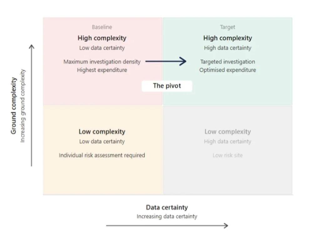
The right scope for the right problem
Investigation effort should be proportionate to ground complexity and calibrated against available data certainty. Our methods move projects from high-cost and uncertainty toward targeted, efficient characterisation.
What we deliver
Agerion delivers senior-level geoscience advisory across the full project lifecycle, from feasibility through to installation support. We work faster, with fewer iterations, and with a focus on getting it right the first time.
Technical due diligence and programme assurance
When ground risk sits at the centre of a critical decision, independent assessment changes the outcome. Agerion reviews ground risk, data quality, and scope adequacy at any stage of a project, connecting every finding directly to the engineering or commercial decision it affects. Pre-submission review of proposals, tender responses, and investigation scopes for fitness for purpose. Real-time support during active operations, and final deliverable review before submission. A consistent quality gate across everything that carries your name.
Structured red flag reporting
Independent ground risk assessments for lenders, insurers, and project finance investors. A clear, structured evaluation of geoscience risk designed specifically for non-technical decision-makers assessing offshore energy assets.
Objective-led site characterisation
Ground investigation programmes designed around the project's actual questions, not inherited templates. From strategy through execution: survey scoping, programme calibration, procurement support, and technical oversight of offshore site investigation operations. Real-time data quality assurance in the field, contractor management, and scope adherence monitoring. Phased approaches that manage client risk at every stage, with decision gates before major expenditure. We ensure that what is acquired offshore meets the objectives defined onshore.
Geohazard and ground risk assessment
Identification, quantification, and mitigation of seabed and subsurface hazards, connected directly to their engineering and commercial consequences. Every risk assessed in context, with clear recommendations for action.
Integrated data interpretation
Integrated interpretation across geophysical and geotechnical datasets, from preliminary screening through to constrained ground models and soil parameter evaluation. Advanced methods including quantitative interpretation delivered through a phased, risk-managed approach with decision gates at each stage.
Quality frameworks and capability development
Reusable delivery infrastructure for consultancies and developer teams. Standardised templates, QA/QC workflows, project initiation procedures, and structured technical mentorship focused on interpretation quality, commercial awareness, and client communication.
Permit and grid connection support
Geoscience input to permit applications and grid connection assessments where ground conditions and geohazard evaluation form part of the regulatory requirement.